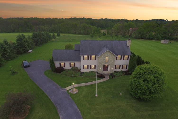
Synversa Drone Services / Aerial Photography
Synversa Drone Services / Aerial Photography specializes in providing expert aerial photography services. Their expertise offers unique perspectives for any project.
About Synversa Drone Services / Aerial Photography
Company Overview
Synversa Drone Services / Aerial Photography is a photography service operating in Pennsylvania that specializes in unmanned aerial vehicle (UAV) technology for capturing images and video from elevated perspectives. The company combines drone operation expertise with professional photography and videography services, offering clients visual content that would traditionally require expensive helicopter rentals or crane equipment.
As a dual-focus operation, Synversa addresses both the technical demands of drone piloting and the artistic requirements of professional photography. This integration of skills reflects the broader evolution of the commercial drone industry, which has grown substantially since the Federal Aviation Administration established Part 107 regulations in 2016 governing commercial drone operations in the United States.
Services and Capabilities
Drone-based photography services encompass a range of applications across multiple industries. Aerial photography providers like Synversa typically serve clients in real estate, construction, agriculture, event documentation, and marketing sectors. Each application requires different technical approaches and equipment configurations.
Real estate photography represents one of the most common applications for aerial drone services. Property listings featuring aerial imagery allow potential buyers to assess lot size, neighborhood context, roof condition, and landscape features that ground-level photography cannot adequately capture. For commercial properties, aerial perspectives can document parking capacity, building footprints, and proximity to transportation corridors.
Construction documentation through drone photography serves project managers, developers, and stakeholders who need regular visual progress reports. Aerial imagery captured at consistent intervals creates a timeline of construction phases, useful for both project management and dispute resolution. These images can also support surveying efforts and site analysis before ground is broken.
Event photography from aerial perspectives adds production value to weddings, festivals, corporate gatherings, and sporting events. Drone operators working events must coordinate with venue management and adhere to FAA regulations regarding flight over crowds, which requires careful planning and often specific waivers depending on the circumstances.
Agricultural applications include crop health monitoring, irrigation assessment, and land surveying. Farmers and agricultural managers use aerial imagery to identify problem areas in fields that might not be visible from ground level, allowing for more targeted intervention and resource allocation.
Technical Considerations in Aerial Photography
Professional drone photography operations require equipment beyond basic consumer drones. Commercial operators typically invest in platforms capable of carrying higher-quality camera systems, maintaining stable flight in varying wind conditions, and operating for extended periods on single battery charges. Camera specifications, gimbal stabilization systems, and transmission quality all factor into the final image quality delivered to clients.
Flight planning constitutes a significant portion of professional drone work. Operators must consider airspace restrictions, weather conditions, lighting angles based on time of day, and potential obstacles in the flight path. In Pennsylvania, drone operators must be aware of restricted airspace around airports, military installations, and other sensitive locations. The state contains numerous small airports and heliports that create airspace considerations for commercial drone operations.
Post-processing work transforms raw aerial captures into finished deliverables. This may include color correction, exposure adjustment, panoramic stitching for wide-area coverage, and video editing for motion content. The integration of photography skills with drone operation distinguishes professional services from hobbyist operators who may possess piloting skills but lack the visual arts background to produce polished final products.
Regulatory Framework
Commercial drone operations in the United States fall under FAA jurisdiction. Operators must hold a Remote Pilot Certificate, obtained by passing the Part 107 knowledge test covering airspace classification, weather effects, loading and performance, and regulations. Certificate holders must also pass TSA background checks and maintain their credentials through recurrent testing every 24 months.
Part 107 regulations establish baseline operational limits including maximum altitude of 400 feet above ground level, daylight-only operations without waiver, visual line of sight requirements, and prohibitions on flight over non-participating persons. Operations outside these parameters require specific waivers from the FAA, which involves demonstrating alternative safety measures.
Pennsylvania does not impose state-level licensing requirements for commercial drone operations beyond federal mandates, though local ordinances may restrict drone use in certain municipalities or parks. Professional operators maintain awareness of both federal regulations and local restrictions that might affect specific job sites.
Service Area and Geographic Considerations
Based in Pennsylvania, Synversa Drone Services operates within a state that presents diverse photographic opportunities and challenges. Pennsylvania's geography ranges from the relatively flat agricultural regions of the southeast to the mountainous terrain of the Alleghenies in the central and western portions of the state. Urban centers including Philadelphia, Pittsburgh, Allentown, and Harrisburg each present different airspace considerations and client needs.
The 610 area code associated with the business phone number corresponds to the southeastern Pennsylvania region, encompassing portions of the Philadelphia suburbs including Chester, Delaware, and Montgomery counties. This area contains a mix of residential communities, commercial developments, and remaining agricultural land, creating demand for various aerial photography applications.
Southeastern Pennsylvania's proximity to Philadelphia International Airport and numerous smaller airfields means drone operators in this region frequently work within controlled airspace, requiring coordination through the FAA's Low Altitude Authorization and Notification Capability (LAANC) system or traditional airspace authorization processes.
Industry Context
The commercial drone services industry has experienced substantial growth over the past decade as technology has improved and regulations have clarified operational requirements. What began as a novelty has become an established tool across multiple industries, with aerial imagery now expected in many professional contexts where it was once considered optional.
Competition in the aerial photography sector includes both dedicated drone service providers and traditional photography businesses that have added drone capabilities to their offerings. The market also includes individual operators working part-time alongside full-service companies with multiple pilots and diverse equipment inventories.
Insurance requirements for commercial drone operations add to the professional infrastructure that distinguishes established operators from casual hobbyists. Liability coverage protects both the operator and clients in the event of accidents or property damage, and many commercial clients require proof of insurance before contracting aerial photography services.
Practical Information
Prospective clients can reach Synversa Drone Services by phone at 610-780-3972. Initial consultations typically involve discussing project requirements, site locations, timeline expectations, and deliverable formats. Factors affecting project scope include the size of the area to be photographed, complexity of the shots required, any necessary permits or authorizations, and post-processing requirements.
Project timelines vary based on weather conditions, which play a significant role in aerial photography scheduling. Wind speeds, precipitation, and lighting conditions all affect both flight safety and image quality. Professional operators build flexibility into their schedules to accommodate weather-related rescheduling.
Deliverables from aerial photography projects may include high-resolution still images, edited video content, raw footage for client editing, or specialized outputs such as orthomosaic maps created from multiple overlapping images. The specific deliverables depend on client needs and intended use of the imagery.
Contact Information for Synversa Drone Services / Aerial Photography
Customer Reviews
No reviews yet.
Working Hours / Hours of Operation
- Monday:
- 5:30-8:30PM
- Tuesday:
- 5:30-8:30PM
- Wednesday:
- 5:30-8:30PM
- Thursday:
- 5:30-8:30PM
- Friday:
- 5:30-8:30PM
- Saturday:
- 7AM-7PM
- Sunday:
- 7AM-7PM
Location Map
Similar Photographers Near , PA




BerksConnect: everything local in Berks County, PA.
8,700+ local businesses with AI-summarized reviews, plus local guides, jobs, and what's happening around the county.